september  2012
2012
So I just discovered this great website, Waite Air Photos (where they "specialize in providing stock aerial photography for use on the Internet to advertise real estate to a world market"). I spent hours looking at photos of Vancouver now compared to 1982, the first year for which they have galleries, which was coincidentally the year our building was completed. It's the one in the upper left corner of the photo (see badly drawn red arrow) and as you can see, it was the tallest building facing south down Granville Street at the time.
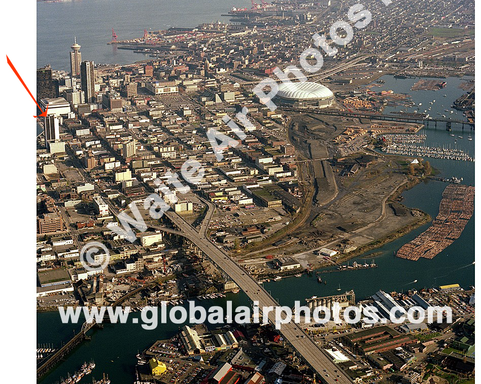 Everything between the Granville Bridge at 6 o'clock and the Cambie Bridge at 3 in the picture is what eventually became Yaletown, but 30 years ago it looked for all the world like a lumber yard (or worse, an industrial part of Seattle). Click to see full size.
When our building opened in 1982 the view to the South wouldn't have been much of a selling point (ah, but have you seen the lumber yard at sunset?) but in 2012 it's a spectacular Blade Runner-esque vista of shiny highrise towers as far as the eye can see.
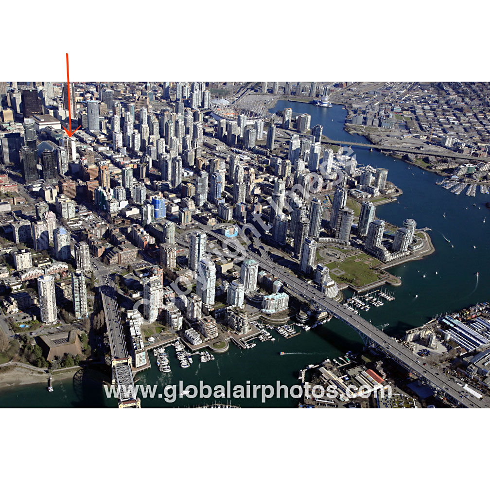 This is the closest I could find to the exact same view in 2012 (again, our building is indicated by the cartoonish red arrow). I like to believe all that concrete and glass has actually changed the color palette of the city, banishing the sawdust, grime and ochre of the previous century for a cleaner, sunnier Vancouver with approximately 50% more blue...
I love aerial photography. I could sit here all day pointing out different places where I've lived, worked, walked, eaten sushi... (Don't worry, I won't.) I just think it's amazing that we now have access to decades of these artifacts to provide a time traveler's slide projector version of what Google Maps/Earth/StreetView were back when they had the power to boggle our minds. I know, I hate to be all "hey, remember 2005?" but if there is any doubt about the degree to which we take the miracle of spy satellite technology for granted, I'm willing to bet the last time you expressed an opinion about Google Maps out loud, it was something along the lines of, "when in the hell was this picture taken?"
Like the other day, I was buying something off Craigslist and I went to look up the guy's address only to find a satellite photo of a gaping hole in the ground surrounded by plywood sheeting (no, he's not homeless — I don't buy furniture from the homeless, only mannequins). But the fact that Google's last pass with the panopticon camera predated the construction of the shiny new tower he lives in hardly surprised me. I didn't even bother to check the date the photo was taken. All the highrises you see in the 2012 photo above seemed to sprout up out of the ground overnight. One day you're walking down a block shrouded in plywood and construction signs, the next day you're admiring your reflection in the tinted windows of a brand new condo's opulent granite and glass lobby.
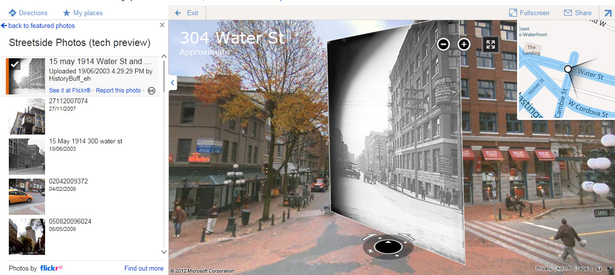
On the other hand, although admittedly I rarely have the presence of mind to type "Bing maps" into Google (and why do I feel like I should apologize when I do? Am I fucking insane?) but when I do, it never fails to amaze me with its crisp, eerily hyperreal images and they (because Microsoft is now a "they" not a "he") keep upping the ante. For example, there's this feature when you're in StreetView or Bing's "Streetside" view where whatever you're looking at has geotagged photos along the side. But when you click them in Bing, rather than doing anything so pedestrian as maximizing, they superimpose themselves into the scene at exactly the same angle and elevation, a trick that brings in a whole new dimension of information (the 4th, if you want to be specific — and nerdy — about it). Although this feature's usefulness might be arguable, it's especially clever when the photo is from a different era, like this one of Vancouver's historic Water Street in Gastown, circa 1914. See, you thought you were just surfing and oops, you learned something new (okay, sort of).
The source of the superimposed historical shot above and many, many more like it is Flickr's "Now and Then" gallery. In a way, Vancouver is a perfect city for Internet histourism. Its 150-year timeline fits easily within the parameters of a "before and after" treatment, neat and tidy and linear, optimized for your screen size of choice. Most places on earth have much messier histories that have been erased and redrawn, bulldozed and plastered over so many times that an Etch-a-Sketch would make a more suitable medium. Even by North American west coast standards, Vancouver's history is short and sweet, whereas cities like San Francisco and Seattle aren't that much older but have already been burned to the ground and rebuilt at least once. If I hadn't committed myself to a day of unrepentant navel-gazing from the very beginning, I might venture outside my comfort zone to see how Bing Maps handles a more complicated city, like London or Baghdad.*
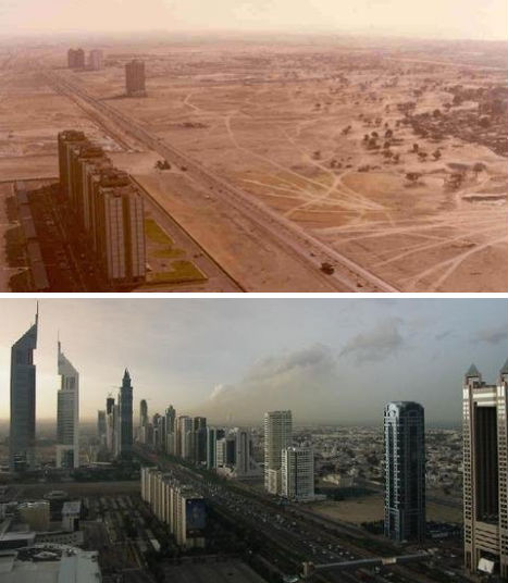
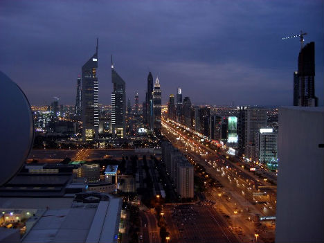
But then Vancouver's rate of change is nothing compared to that of Dubai (below: 1990, 2003 and 2007)...
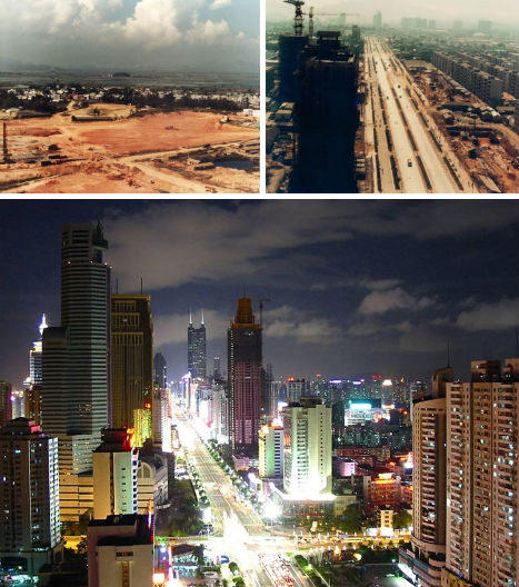
Or Shenzhen (1979-2010). Photos courtesy of WebUrbanist.com (I guess — it seems like they're everywhere uncredited).
[*Postscript: It will come as a surprise to no one that Baghdad doesn't have StreetView or Streetside View.]